
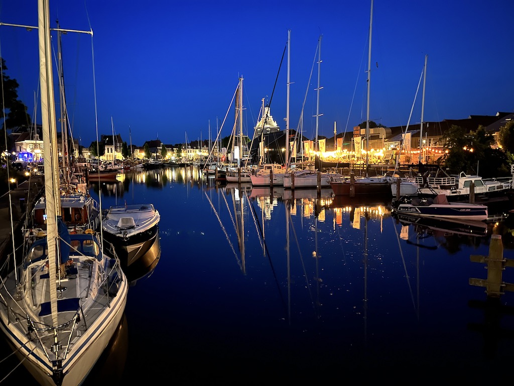
One of the curious oddities of boating in the Netherlands is the extensive network of inland waterways. We had already been on our first one – the North Sea Canal that runs into Amsterdam from the sea – but the guide book described countless others running in all compass directions, like the fissures running outwards from a cracked window. We knew they had not been built specifically for pleasure boaters – that point was made crystal clear by the numerous fleets of commercial ships plying the waters – but what pleased us was the numerous miles of ‘mast-up’ routes. Commonly, these inland waterways are crossed by low-slung bridges, forcing sailboats to either skip the route or remove their mast and rigging. But the Netherlands had made a concerted effort to accommodate taller vessels, either by constructing bridges much bigger, tunneling roads under the water, or installing lift bridges. As we eased away from the dock in Amsterdam, and passed through the blink-and-you’ll-miss-it lock at curiously named Oranjesluis, which raised us a meer 6 inches, we waited patiently for the bridge at tongue-twister named Schellingwoudebrug to open for passage. Unfolding before us on the other side was the massive inland body of water named Markermeer.

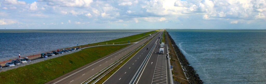
The Markermeer, covering nearly 300 sq miles, is a man-made lake in the center of the Netherlands, bordered on all sides by large earthen dykes. The northern dyke separates the Markermeer from its twin sister, the IJsselmeer, coming in at an even more impressive 425 square miles. The IJsselmeer, in turn, is isolated from the North Sea by the 20 mile long Afsluitdijk, a distance so substantial it seems to carry off over the horizon. These dykes are no amateur effort with picks and shovels. The Afsluitdijk in particular is 300 feet across and accommodates a multilane roadway. Considering that this was all accomplished back in the 1930’s and completed 2 years ahead of schedule is a monumental achievement that should stir the pride of every Dutch person.
Prior to the Markermeer and IJsselmeer, this area was called the Zuidersee (South Sea), a shallow salt water inlet separated from the often-tempestuous North Sea only by off-lying barrier islands. Small towns grew up along the banks of the Zuidersee, first starting out as fishing villages and later as trading ports serving Northern Europe as part of the Hanseatic League. During Holland’s colonial era, trading extended to ports all throughout the world, and local towns such as Hoorn and Enkhuizen became the home ports of substantial wooden sailing ships crewed by rugged men with deep experience on the high seas. But Mother Nature had other plans. With its exposure to the North Sea, and periodic storm surge through the barrier islands, flooding was frequent along the Zuidersee, causing damage to the towns and their ships. Finally, after wide spread flooding in 1916, plans were swiftly put into place to close off the Zuidersee. Food scarcity at the end of World War I also drove the government to find new arable land to improve the country’s level of self-sufficiency.
As a visitor today to the region, one can walk, bike or drive along many of the dykes that hold back the waters of the Markermeer and IJsselmeer. At these higher vantage points, you can look down to farm land, grazing pastures, homes and villages all below the water level on the other side of the dyke. In many places, the reclaimed land is 4-5 meters below the water level. These areas, called polder, have been reclaimed from the sea by pumping out the water and working the soil for up to five years before it can be effectively used. The scale of human effort to transform these lands is mind-boggling. And with sea levels rising, the challenge continues. A project was launched in 2019 to increase the height of the Afsluitdijk by another 2 meters, at a cost of nearly $1 billion dollars. It all makes one wonder if these herculean efforts to combat Mother Nature still make practical sense.

For now, there are some incredibly charming sites to see along the Markermeer, and we wasted no time putting Amsterdam to our stern to find a spot to anchor behind the tiny island of Marken. The Markermeer is very shallow, and for much of our journey, we stuck to the designated shipping channel with a depth of 4 meters, until we were forced to exit the channel for our anchorage. Depths became a conversation-stopping 2.5-3 meters. We began to see long weeds and grasses coming to the surface from the seafloor. We both started to wonder if the boat was slowing down as the keel touched the mud. This was not a body of water to amble about on a lazy afternoon, but at least there was no tide to worry about. For the next several days, we would enjoy not having to check the tide tables and doing the mental math that accompanies anchoring in tidal waters.
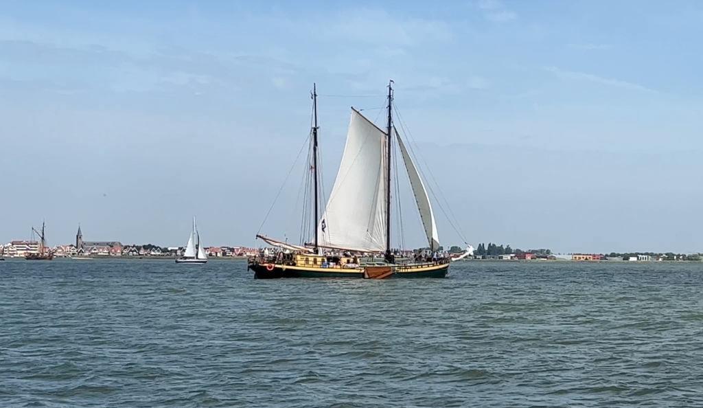
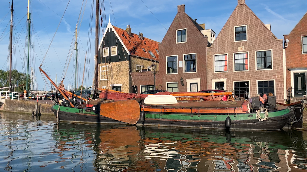
Marken is centrally located between the deeply historical towns of Volendam and Monnickendam. Before we had a chance to launch the dinghy to go ashore, traditional old Dutch sailing ships with their distinctive wooden leeboards on the side of their hull criss-crossed in front of us. These flat-bottomed trading ships were widely used in the 18th and 19th century in this region, as they could navigate into shallow harbors with the leeboard up, but capably sail out into the North Sea with their leeboard down.
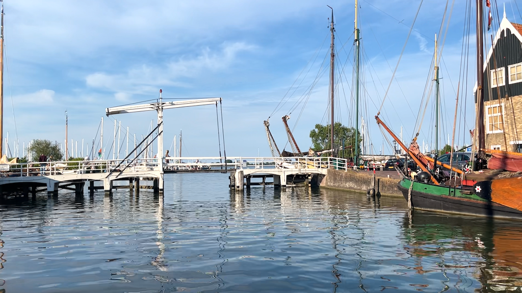
The crafty engineering of the Dutch is not limited to sailing ships, however. Throughout the town of Volendam were elaborately constructed wooden lifting bridges, with hefty counter weights overhead, to cross the inevitably large number of local canals that come with a town prone to historical flooding. Amsterdam was exciting and vibrant and trendy, but here you truly felt like a time traveller witnessing early Dutch way of life.


With just the two of us and our beefy 15hp outboard engine full of testosterone, we made quick work of the dinghy ride from Volendam down the shore to Monnickendam. To be sure, Karen held firmly to her phone with the Navionics chart app as we cut through the light afternoon chop, making sure we avoided several shallow dykes just below the water’s surface.
If Volendam was a trip back in time, Monnickendam was charm on steroids. Every turn of a street corner revealed an eye-pleasing view of traditional Dutch architecture, shipbuilding and engineering. Not surprisingly, our dinner, served on a tipsy floating barge on the main canal, was one of the best fish stews we’ve ever had.

In the morning, breezy conditions forced us to ditch plans to dinghy ashore for much needed groceries. Alternatively, we raised an anchor full of mucky clay-colored mud interspersed with seashells and hoisted our code 0 for a downwind run up the Markermeer. The long dyke that separates the Markermeer and the IJsselmeer has two locks for passage between the two bodies of water – one on the extreme western end and the other on the eastern end. The western lock is adjacent to the town of Enkhuizen, which came highly recommended by other boaters we met, so it didn’t take much deliberation to continue our sail north, watching the depth sounder closely as it hovered in low single digits, all the while shaking weeds off the rudders as we went.

But first we needed to bumble our way through another lock of the witness protection program. Once again, no information was available online or in print on how this lock was setup. Should we put fenders on port or starboard? What is available to tie to and therefore should we have short or long lines, and at bow, stern and amidships cleats? Is there a fee? Will we downlock or uplock and by how much?
We doused the Code 0, taking our place in the slow motion cattle stampede of sailboats forming a maritime funnel into the lock entrance. An older couple on a Netherlands-flagged boat tied up on the starboard side directly ahead of us and without asking went up and down the lock wall to lend a hand to other boats. I inquired with them on how much up or down we would go, and they shrugged the question off with polite Dutch hospitality, squeezing two fingers close together showing how trivial the water change would be. Indeed, no sooner had the lock gates closed behind us, the gates ahead of us opened up and the stampede of boats throttled up to be the first out the exit. One purpose of these locks is to handle storm surge, particularly at an astronomically high tide, so it is possible the water level change would be more pronounced during those periods.
I had called Marina Compagnieshaven, just on the other side of the lock, earlier in the day to make a reservation, but they refused saying we could just show up and be assigned a ‘box’. That was all good, but, like the lack of details on the locks, we didn’t know where to go to get this assignment and the term ‘box’ was a new one for us. As it turns out, it is a common term in this region for a dock space that is bounded by wooden pilings on the outer corners, instead of a finger pier. There may also be pilings on the inside corners of the space (thus, the term ‘box’), or simply cleats along the pontoon to tie your bow lines to. We held back from the crowd of boats to see where everyone else went to in the marina. A bunch of boats were tying up to an outer face dock, and a man waved at me to come in when I asked where do we go to get our assignment. While it appeared from afar that he worked for the marina, he was in fact just another friendly boater thinking we wanted to dock next to him. Other boats were going down a long center fairway and circling back around. There’s no joy driving a 10 ton boat with a meager 57hp engine around a crowded marina trying to figure out who is in charge and where to go. We finally found a young guy in a little hut with a clipboard, a sure sign of authority. He asked for our beam (width of the boat), to which I replied 4.2m, per our boat spec, and he shouted out a dock number for us to use for the two nights we would stay here in Enkhuizen. Normally, you put out fenders on both sides of your hull as you come into a space, but with a box, the fenders can get caught up on the outer pilings, as they rub down the side of your hull. We quickly flipped the fenders up on to the deck, and Karen slowly put our bow directly in between the outer pilings. I had to shove off the starboard side so it wouldn’t scrape our hull, but all was good until we got to the widest part of our hull, right at amidships. The boat came to a complete stop. Both pilings were pressed tight against our port and starboard quarter and Sea Rose would not move. Either we were wider than 4.2m or the box was less than 4.2. With extra throttle in reverse, we eventually removed ourselves from the piling pinchers, but we couldn’t find the man in the hut for a reassignment. Karen dropped me off so I could find the marina office, where they were a bit annoyed that our boat was wider than I had told them (their assumption). They switched us to another box that was an oh-so-generous 4.4m wide. This box was a pincher as well, but with enough shoving and pulling and petrochemicals, we squeezed in, secured our lines, and cracked open a couple of beers. Fateful for us, in the evening, music started drifting over the roof tops from the center of Enkhuizen, and like a couple of mice sniffing around for fresh cheese, we found a live band on an outdoor stage with tons of people half our age dancing, drinking and cavorting. After the isolation of Covid, this was the age group that needed to burn off steam the most, but we did our duty to sing along and spill beer like the best of them.


The village of Hoorn, a morning bike ride away from Enkhuizen, continued to heap on the Dutch charm. It has a rich maritime history of trade, being the home of the Dutch East India Company. At its peak in the 17th and 18th century, they controlled world-wide trade routes with their fleet of over 4000 ships. Their next largest competitor, the British, had just 1/5th the ship tonnage. The bike route following the crest of the dyke, allowed us a bird’s eye view of the high water on one side, and the agricultural and residential land at least 4 m below the water on the other side. My thoughts floated to our own New Orleans, a city below sea level riddled with historical flooding, with the U.S. Army Corps of Engineers struggling to keep up with Mother Nature’s attacks on the system of dykes surrounding the city. You wouldn’t catch me buying a house or a farm here or in New Orleans, but somehow the Dutch have mastered the construction of these manmade roadblocks to severe weather better than any other country world-wide. Their once-mastery of the ocean-going trading routes has pivoted into a modern-day prowess of holding back the power of those same oceans.


We pushed on from Enkhuizen to plot our exit plan from the safe haven of the IJsselmeer. At the extreme east of the Afsluitdijk, separating the IJsselmeer from the Wadden Sea, was the big ship lock of Kornwerderzand. It lay directly upwind from Enkhuizen. I normally don’t find much joy in tacking upwind but the beauty of these inland waters is the lack of swells and breaking waves. We sheeted in the sails on Sea Rose as she heeled over and accelerated upwind. This is her element – smooth water with a healthy wind. We tacked frequently to stay in the deeper channel of the IJsselmeer until we passed a wind farm of 89 turbines, so new that it didn’t appear on the nautical chart, and settled into a protected anchorage adjacent to the Kornwerderzand lock. We weren’t quite ready to exit the IJsselmeer. On the other side of the lock, we’d be leaving the innocence of tide-free sailing. An extremely narrow channel wound its way out to the Netherland’s northern barrier islands along a track that we could only navigate during the upper half of the tide cycle. Specifically, we’d have to exit the lock at exactly half-tide rising in order to give us enough water depth for the entire day’s journey. Further, we had several long sunrise-to-sunset days ahead of us as we sailed outside the barrier islands, the only route with enough deep water to get to the Kiel Canal. We would be passing through a section of the North Sea called the Germany Bight where northern winds and swells get compressed as the coastlines taper inward, leading to very rough conditions. A modest weather window was going to be critical. With Sea Rose still protected inside the massive dyke, we could properly spend the evening researching all of our weather and navigation sources, and mentally prepare for the physical challenges ahead of us. These times are a reminder to me how fortunate I am to have a sailing partner who takes safety seriously. We could worry all night long but that wouldn’t remove the inherent risk in our chosen adventure onboard a small boat on big waters. Instead, we would work on managing the risk – double-checking our safety gear, determining backup ports or anchorages, and getting good rest and nutrition. Back to the real world!
Be sure to also checkout the video content on our LifeFourPointZero YouTube channel. We regularly post updates on our sailing adventures, as well as how to videos on boat repair, sailing techniques, and more!

I just love reading the details of your trips. So amazing! (But glad you’re home)
Thanks Shelly!