
This past week, the residents of Thalia participated in several activities and events which fell neatly into the “normal” range — something new for us! Although, with just over one month left of our adventure we are anticipating an abrupt return to lives filled with “normalcy”, day in and day out! I don’t think we are able to articulate — from our current perspectives — what this next major shift will mean to each of us. I, for one, have such a mixed set of feelings about our life back on land that I am truly perplexed with how I will respond. Time will have to tell this one.
We began this week at ICW (Intracoastal Waterway) mile marker 157 as we tossed the lines off from the rustic commercial dock of RE Mayo and Company and traveled the 22 miles to Belhaven, North Carolina. We had heard there was a full day of family activities in Belhaven on the 4th of July so we decided to get there on the 3rd to get hooked into the local scene.
Each new town presents itself to us, the visitor, in unique ways. Our interface with the many towns we have arrived at has come in all shapes and sizes. Some towns have very welcoming and accessible waterfronts with clear and inviting signage. Others have next to nothing, and leave the visitor questioning their decision to stop. We have yet to find a town which does not want boating transients to come ashore; however, the disparity in the means of getting there voices an accurate preview of how welcome visitors will feel in the town. This week’s two towns are at each end of the spectrum on this account, yet are only 85 miles apart geographically.
Along this section of the ICW, we again find ourselves in narrow canals and dredged creeks which were built to connect the sizable Neuse River to our south and Pamlico River to our north. Right now, we navigate “Goose Creek”. These days are extremely hot and the small cuts of waterway shrouded by all manner of foliage keep all but a stiff breeze away from us. We often think back to the days of diving into the crystal clear waters of the Caribbean Sea. And, while we no longer see an abundance of alligator along the shores, we still timidly avoid the water in these parts. Maybe it is the thick root beer/mud color but on the hottest, humid day I think I could overlook that. Yet, the nearly constant sightings of jellyfish throughout these waters is reason enough for me to stay securely onboard. So, we make use of a spray bottle — our pretend squirt gun — to do the cooling for us!
We are thankful when Goose Creek finally releases us into the expanse of the Pamlico River. To the west, the Pamlico river opens up into the huge Pamlico Sound, one of the major bodies of water enclosed by North Carolina’s Outer Banks. Ah, a chance to raise the sails as the open water gives us access to a nice breeze! We cross the Pamlico River and head up the Pungo River and into Belhaven, which is on a creek off the Pungo called Pantego Creek. The creek is very wide off of the town of Belhaven and we have our pick of places to anchor in perfect depth! What a treat. Being off of the Pungo River, this area can become very choppy in the afternoons when the winds are typically at their strongest. Yet, it all seems to quiet down at night for a pleasant, gentle rolling night’s sleep. I often wonder if I’m going to have to have my bed at home suspended off the ground and outfitted with an automated rocking arm in order to get a good night’s sleep after this year! I’ll also need a gentle breeze blowing down at me from above like our opened hatch affords. And, to think I wondered if I would adjust to sleeping night after night on our floating home!
Belhaven, NC ~ Going ashore in Belhaven should be easy. There are TONS of docks everywhere — mostly empty?! Humm … The cruising guide mentions a dinghy dock next to a hospital so we tie up at a rickety, tiny dock which we are afraid to have more than one of us on at a time. No other dinghys in sight. Another Hummm … We walk away from the water for a distance roughly equivalent to two city blocks and find the town’s main street running parallel to the water. Down a few blocks to the right, this street T’s with another and this intersection forms the heart of the city’s commercial center. The connection between waterfront and commercial heart–while only two blocks apart–feels somehow disjointed. Even though there is a small amount of open space available on the waterfront, it is not inviting. No park benches or boardwalks. Not even a contiguous sidewalk connecting this area of great potential to the nearby commercial heart.
We all find it fascinating to see how each town has chosen to interface with their waterfront. The waterfront is our main highway into their town; and, thus, our introduction to the community. Think for a minute of entrances to cute villages which pop into your mind… There are often welcome signs and pleasant landscaping. Maybe there are fountains or statues nearby. Buildings of notable architecture and maybe even a spot where the traffic separates into one way streets around a town square… Sure, most of these waterfront towns have been laid out for at least a century so maybe they have little choice over the matter. However, the waterway was, arguably, more important to these towns during their formative years than it is in present day — at least from a practical perspective. During the settlement and early development of these coastal towns, travel and shipping on the water was much easier than over land. One look at a detailed map of any of the areas we have passed through on the ICW will illustrate the difficulty of land travel in a time before bridges and raised roadways. There is extensive swamp land throughout these regions and creeks, rivers and sounds slice up the remaining solid ground making it nearly impossible to travel on land for any extended distance. Besides, in the present day, these towns are visited by hundreds of pleasure boats making the seasonal trek from north to south and back again. So many of the towns we have visited have made a beautiful interface between their commercial streets just off the waterfront and what ever dockage or landing accommodations they have available for visiting boaters.
We are still holding out hope for Belhaven, however, as we have learned of several waterfront revival efforts by cities and towns which have been hugely successful. Both area residents and boaters are reaping the rewards of projects such as these. I think of Beaufort, South Carolina and the tremendous job they did on their waterfront! The Beaufort River runs swiftly against a seawall which is lined by a wide, nicely landscaped walk-way. Next to the walk way is a line of probably 15 to 20 bench swings. Behind these swings is an open grassy area which is probably used for summer concerts. Opening up onto this grassy area are the backs of all the commercial establishments which line the commercial heart of their lovely town’s main street. Many of these businesses have created a rear entrance and covered patio with interesting brickwork. Great job, Beaufort! We dined on this waterfront on a weekday evening and the whole waterfront was alive and packed by what we understood were locals. Pleasant and inviting to the boater, enjoyable for all. Very nice job.
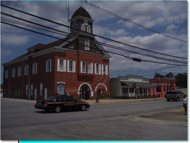
Ok, so what did we DO in Belhaven?! The afternoon of July 3rd, we walked around the town, learned of the 4th of July’s festivities and visited their local museum. What a funky collection of stuff! It almost felt like a barn sale of dusty and antique artifacts. Yet, I thoroughly enjoyed it. It seems there was a woman in town who collected tons of random stuff as it achieved “antique” or unique status. She began opening up her home to additional contributions and to visitors who wanted to view her collections. As more people learned of her efforts, more and more stuff came her way. As she approached a frail age, the town’s historic society decided it was worth making a museum out of her ever-growing collections. We saw everything from antique farm tools, typewriters, clothing and furniture to the bizarre display of pickled specimens of animal birth defects, tumorous growths, human fetuses and skeletons and snake skins. What a hoot! Normally, I’m the one with a somewhat weak stomach … not this time. Our youngest and I marveled at the many pickled items while Tom could barely look upon them. For weeks afterward, he wouldn’t even allow us to discuss them! Well worth enduring the dust. Here is a picture of the historic building which houses the museum in the upper floor. You will notice that the lower floor serves as both the Town Hall and the Police Department — small town America!
That evening, the town’s center open-space was transformed into a fair complete with simple rides for kids, food vendors, games and an art exhibit. As the sun set, the street through the center of town was closed off and a DJ played a mix of country music for a street dance. We stayed for a while, but our kids are not crazy about sitting and listening to music. When I suggested they participate in the dancing, the evening arrived at an abrupt close! I wonder if our kids will ever dance…
The following day, we again returned to the fairgrounds to take part in more “normal” 4th of July activities! “Normal” for these parts, anyway! The parade kicked off at 11 am with a marine helicopter “fly-over” — which is to say that a huge apache helicopter flew just above the power lines down the streets along the parade route! Whoa … this was a not-so-subtle reminder that we were in an area of the country known for their armed services participation. It was extremely cool, I had to agree with my three “kids”! Check this out!
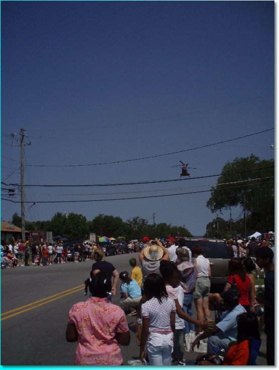
The photo doesn’t do justice to the size and sound of this beast! The “marshall” of this parade was the memory of a young man from the town who had recently lost his life in Iraq. A picture of him in his dress uniform beautifully displayed on a flatbed was the first component of the parade after the fly-over. I couldn’t help think about the sizable contribution this and other small, southern towns have made to our efforts in Iraq. God bless our servicemen and their families. May we bring them home soon.
This parade reminded me of ones I witnessed as a small child in upstate New York as there were brightly shined fire trucks from this and many of the surrounding towns, souped up cars with banners supporting local businesses or politicians, candy thrown from the vehicles to awaiting children and … tractors! This area has deep roots in agriculture. Here are a few old treasures…
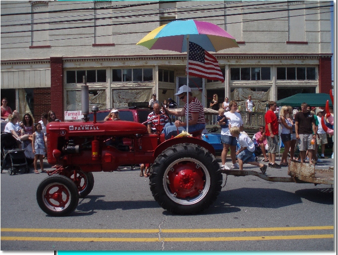
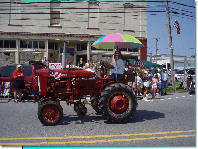
Notice that this Farmall tractor above is from 1947 and the one below is from 1961. Impressive that these are still running … and probably still in use!
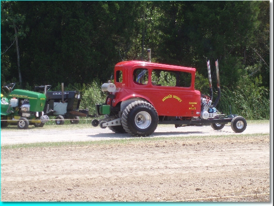
After the parade, we had to show the kids the “lawn mower pull” … today’s version of the “tractor pull”. Those of you from urban and suburban areas may have never seen one of these events. Each tractor (or lawn mower) entered in the event is attached in turn to a sled with weights which the tractor/mower attempts to pull along a dirt roadway. The tractor/mower which pulls the farthest wins. The further the tractor gets along the roadway, the deeper gravel becomes, making the pull increasingly more difficult. Modern versions of this event have established a means of increasing the weight of the sled as it is pulled progressively along this roadway. High tech! Here is one of our favorite “mowers” … this one falls into the “modified” category for obvious reasons!
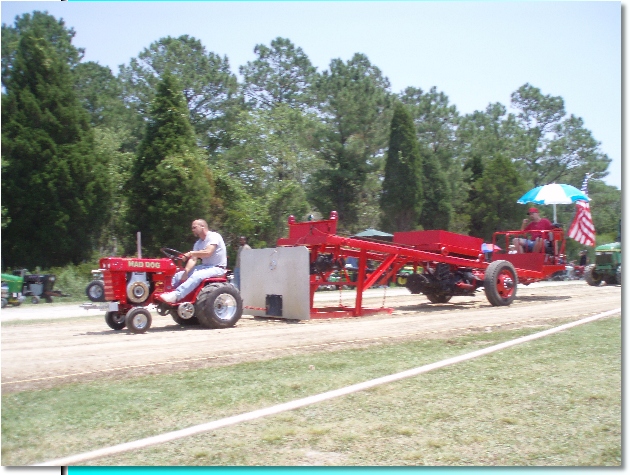
Here is a more traditional one bulling the “sled”… the red box on that strange ride-along contraption moves up the ramp as the “sled” moves along the roadway, adding more weight to the thing being pulled along by the lawn mower!
I definitely felt taken back about 35 years to a time when my grandfather had a beef cattle farm in upstate NY and tractors were a part of my everyday world. In a way, it felt pretty normal to be watching this event!
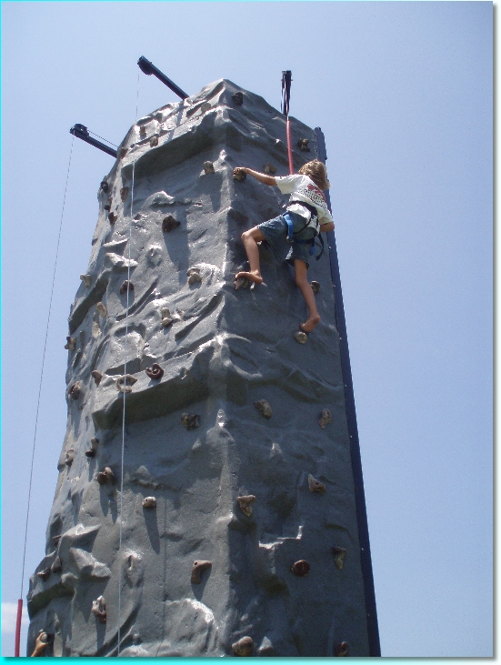
While the kids were a bit old for most of the rides, our youngest did enjoy reawakening their passion for rock climbing on this portable rock climbing wall.
That evening, we watched the great Belhaven fireworks from the bow of Thalia. How cozy it was to wrap up in fleece blankets and sit against our kayaks and take in the surrounding boats, harbor, stars and colorful fireworks.
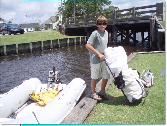
The following day brought us out of our festive mood as we attended to laundry and boat maintenance. Tom had a much needed part shipped to an area marina and it was to arrive on July 5th. With a good hardware store right in town, we decided it would be best to install it immediately in case we needed additional parts or tools. As he putts around with that, I set off for laundry duty. Laundry is one of those tasks I dread while living on the boat. When we all get to the bottom of our clean undies pile I know it is time … I bag up all our dirty clothes, towels and sheets and pack quarters, detergent and our rolling luggage cart and set of in search of the nearest laundromat! Belhaven had one of the shortest walks to laundry services of all places we have visited. Here is Zachary helping me bring the clean, folded laundry back to the dinghy for its final transport back to Thalia. This is one task I will definitely NOT miss when we again become land lubbers.
Time to move on … On the morning of July 6th, we departed Belhaven enroute to Elizabeth City, North Carolina, which would be a two day journey totaling 85 miles. We planned the longer leg of 51 miles for the first day. This would take us further up the Pungo River and then through a 20 mile man made canal called the Alligator River/Pungo River Canal. For the final 20 miles we were able to sail as the Alligator River widened up. We anchored just north of the Alligator River Swing Bridge, outside the entrance to the Alligator River Marina. After a walk ashore to stretch our legs and obtain gas for our dinghy’s outboard engine, we called it a night.
We had about 35 miles to go to Elizabeth City, so on the morning of July 7th we left early. Not even 4 miles into the day’s journey, all of our navigational aids (chart plotter, paper charts and guide books) couldn’t keep us out of trouble as we attempted to navigate through a narrow passage between two increasingly encroaching shoals. We did what all of our aids told us to do and we ran squarely aground — no doubt in our minds on this one! Luckily, there was a mud bottom as so much of this area has. Regardless, however, it is never fun to have your floating home come to an abrupt halt. We were transiting the area quite slowly as we were noticing that the depths our instruments were registering did not synchronize with what we were suppose to be seeing — at least according to all of our previously mentioned navigational aids. Again, we deployed Tom in the dinghy with the hand-held depth sounder to find a safe passage through the shoals. To think that I thought poorly of Tom’s purchase of that little gadget. I now kiss the hand-held depth sounder goodnight each evening! The remainder of the journey passed without incident and by nightfall we found ourselves stern-to in one of the 14 free finger pier docks along the Elizabeth City Waterfront.
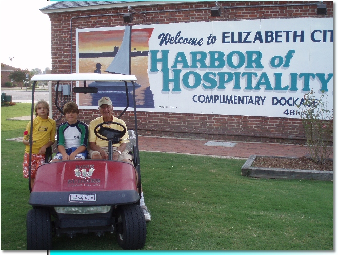
Elizabeth City ~ Harbor of Hospitality
The welcoming nature of this harbor is the opposite of what I described about Belhaven. What a charming waterfront this town has developed and maintained. Three elderly gentlemen welcomed us into town by suggesting which finger pier would best accommodate our wide berth and significant depth. After all lines were secure, we disembarked and chatted with what we learned were representatives of “The Rose Buddies”, a volunteer organization which makes Elizabeth City the hospitable harbor it has become famous for — literally! It turns out that many years ago several local very social men began bringing a rose to each woman aboard a boat at the town’s docks. This same group also began having wine and cheese events whenever there were five or more boats at the docks. This outpouring of generosity and welcoming earned these “Rose Buddies” a spot on the today show some time back and the open-armed traditions continue to this day. A 93 year old man drives along the waterfront in his gulf cart and snips a rose from the gardens which the group planted nearby for the purpose. While he enjoys conversing with everyone, he has a special place in his heart for women and truly loves handing out the roses. We were invited to one of his evening wine socials and we gladly went. What a dear set of people these Rose Buddies are. Below, our kids accompany Fred Fearing in his golf cart on one of the many lawns along this brick-lined waterfront.
To ensure that the dock spaces along the town’s waterfront remain free to transient boaters (for up to 48 hours), area businesses have sponsored a dock or two. Plaques embedded in the walkway indicate which docks are sponsored by which businesses. A kiosk on the waterfront provided brochures to area attractions and a posted notice gave a phone number of a grocery store in the area that would come pick boaters up at the waterfront and return them after they had shopped. This town understands how to extend the welcome mat!
Ever since we have known we would transit up the ICW through North Carolina, we have hoped to make it to the Outer Banks and especially to Kitty Hawk – site of the Wright Brother’s first flight. We looked at several options on the pages of our nautical charts, but it was proving nearly impossible to get there with Thalia. We didn’t want to miss this region while we were so close, so we decided to leave Thalia in Elizabeth City while we rented a car and stayed in a hotel for two nights. The timing worked out well since we need to pick up my dad on July 11th from the Raleigh/Durham airport. A few days on the Outer Banks and a trip to Raleigh will make good use of our rental car!
The first afternoon, we visited the Wright Brothers National Monument which is run by the National Park Service. We took a guided walking tour of the grounds where the Wright brothers tested several flying machines over a four year period (1900 – 1903). The knowledgeable presentation gave a thorough history of events and developments which led up to successful flight of heavier than air, manned and mechanized aircrafts. The site maintains a terrific museum on flight and several interactive programs designed to teach the principles of flight. Another terrific national park that is well worth a visit.
Amid time on the beach and at the hotel pool, we made time for a play in an outdoor theater on nearby Roanoke Island, a 12:01 am showing of the newly released fifth Harry Potter Movie – Order of the Phoenix – and a trip to the Cape Hatteras National Seashore and historic lighthouse.
The play we saw on Roanoke Island is called “The Lost Colony” and it tells a compelling story that celebrates the 117 English men, women and children who were the first English speaking colonists in the New World. The story, in brief … Englishman Sir Walter Raleigh sought support from his queen, Queen Elizabeth, to establish an English colony along what we now know as North Carolina. Although the Queen was reluctant to release ships to colonization efforts that she felt might be needed to fight against Spain, she eventually agreed to send a small, initial contingency of 117 persons. Once war broke out with Spain, Queen Elizabeth would not allow subsequent trips to the New World, even though it was known that the colony was in desperate need of additional supplies. When an expedition was finally sent, they found no sign of the colonists nor any solid explanation of how they disappeared. Subsequent exploration of this region has yet to discover the true nature of the demise of this colony, some 400 years later. This drama celebrates its 70th season of summer productions this year (2007). We were so thrilled to have learned of this production and the history upon which it was built.
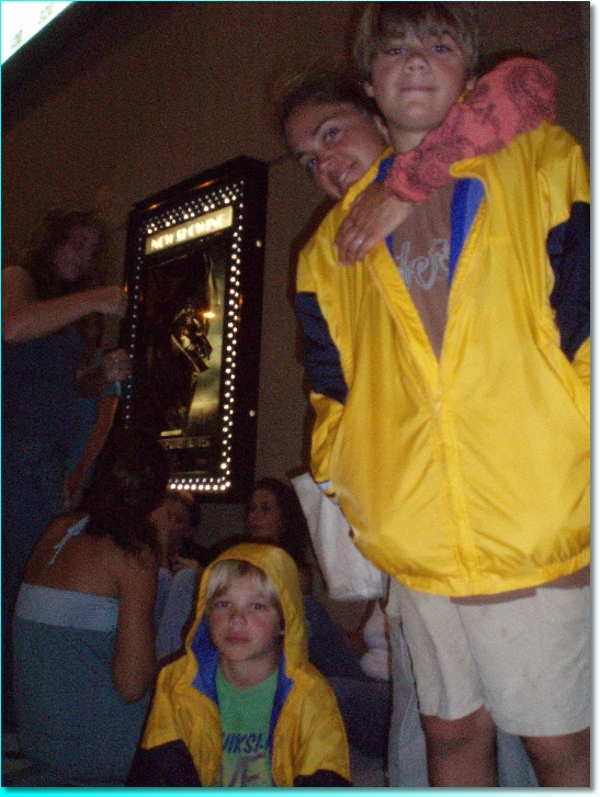
The next night had us out late again! The following day was the release date for the much awaited 5th Harry Potter movie. All of us were anxious to see it and as I looked at our upcoming calendar I didn’t see a good time to fit in a trip to the movies. Through a bit of internet research, Tom learned of a midnight (12:01 a.m. actually) showing. Were we all up for this? Yes, we ran to the nearby theater, purchased tickets then set off for a quick and early dinner. We decided to get sleep before needing to get in line, so by 6 pm all of our heads were on our pillows and our alarm was set for 10:45 p.m. Here is a picture of us in line outside the theater.
Luckily, we had a lot of driving time the following day. Was it worth the trouble and the tired kids? Yes, definitely! We all had a great time. We are all big Harry Potter fans so it was quite a thrill to see this early viewing … and better yet, at midnight!
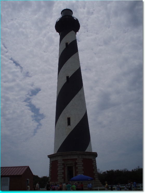
Wow, what a LOT of driving we did today! We checked out of the hotel in Kitty Hawk and drove southeast down the skinny outer banks, onto Hatteras Island and to a point called Cape Hatteras. The landscape of dunes and water was lovely and the effort to get to the cape was worth it. For mariners, this is a very significant point of land on the Atlantic cost of the US. It is the eastern most point of land that the Gulf Stream follows north from near the coast of Florida. The stream, at Cape Hatteras, takes a pretty sharp right turn and heads off the coast. If you have enjoyed the Atlantic Ocean waters below Cape Hatteras, you were probably in water at least 10 degrees warmer than swimmers and surfers north of Cape Hatteras. Here is a picture of the cape as seen from the top of the Cape Hatteras Lighthouse, looking west over the cape.

I know the horizon is hazy, but the point in the center of the photo is truly a point of land, the end of the land seen to the right of the point is beach with ocean beyond …
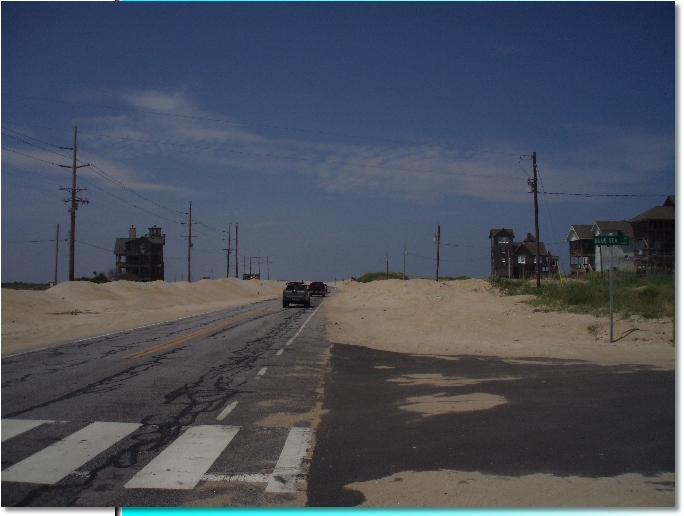
This entire coastal region of North Carolina is known as the Outer Banks. The banks are made up of narrow sand spits of land which nearly connect to two key islands, Ocracoke and Hatteras. There are two huge sounds between the mainland of North Carolina and the “Outer Banks”, Pamlico Sound and Albemarle Sound. Almost all of the way along the skinny Hatteras Island, a person standing on top of the dune next to the road would be able to see both the ocean breakers and the sound’s waters! This next photo is taken in one of the most narrow sections of Hatteras Island.
And, of course, the very famous Cape Hatteras Lighthouse …
The distance from Kitty Hawk to Cape Hatteras and back was significant. Add to that a drive from Kitty Hawk to Raleigh, quite a ways inland, and then back out most of the way to where we left Thalia — Elizabeth City. My dad’s plane arrived around 8 pm and it was great to see him. It had been just over a year since we all saw each other last, an especially tough year for him. While Tom and the kids sleep most of the way to Elizabeth City, Dad and I catch up. I remember being very happy he had the stamina to stay awake and talk with me as I was exhausted by the time we greeted Thalia at 1 am! After the traditional “hi Dad, glad you made it” beer, we all passed out and slept like logs!
Yup, I told you it was a time for the Thalia residents to experience a bunch of pretty normal activities: 4th of July parade and fireworks, visits to a few national parks, a couple nights at a hotel and watching a newly released movie! We could be living anywhere — happily, we are living aboard Thalia, our floating home.