
If they can measure aging from week to week, this has been one week that has tipped the scale towards convalescence sooner than nature intended! Does anyone know where Grecian Formula is available in bulk?! I guess we should have known this would not be easy, trying to put 800 miles under our keel from Puerto Rico to the northern Bahamas before the hurricane season officially started June 1st. But it wasn’t just the mileage that we had to conquer, it was the crazy navigation needed in these shallow and storm ridden Bahamian waters.
After resting up and enjoying the small settlement on the island of Grand Turk, we weighed anchor last Saturday for a 70 mile jaunt to Providenciales (“Provo”). We would have preferred to stay longer in Grand Turk or skip Provo for the southern Bahamas, but we needed more diesel and could use a topping off of water before our next passage. Provo was written up in the cruising guide as a place “you will go to” while in the area. It did seem like it had a lot of services, but with our 7 foot draft, I was having a hard time finding a fuel dock we could navigate into and fill up. I did find one on the northern part of the island, called Leeward Marina, that had, if we wanted to dance with coral heads, enough water to navigate through. So, with a bit of wonder on what was the attraction in Provo, we left Grand Turk and sailed around the string of nearly uninhabited Caicos islands. Our first excitement came in the form of those big, dark, billowy clouds that seem to materialize out of nowhere these days… thunderheads! We began tracking the rain on the radar, and it quickly became a family affair, with our youngest timing the lightning-to-thunder interval on the stopwatch and the rest of us trying to guess in which direction they were moving. As if to play with our vulnerability, the thunderstorms seemed to respond to our course changes with related changes. Don’t they know it is not fair to pick on the little guy? Nothing can make you feel more exposed than sailing on a big wide expanse of water with a 50 foot tall metal stick tempting the lightning bolts to pick you out of the one man audience. You can definitely say that all of our brain cells were focused on avoidance strategies! But as feeble as Mother Nature can make you feel, she can just as quickly change the venue, and within an hour the skies were clearing and we were out of harm’s way. It was time to motor on in the newly calm seas to the entrance to Leeward Marina. Crew positions were assigned – with Karen at the helm, Zack on the bow, me scouting from atop the boom, and our youngest calling out the depth readings from the cockpit. Our first excitement came as we came around the stern of a cabin cruiser that was trailing fishing lines. We could see that they were bringing their lines in, so we weren’t too worried. Then, Zack, on the bow, said “Hey, we are running over a fishing line!” It seems that one of the guys was still fishing while all of his buddies had reeled in – go figure! Sure enough, about 200 feet away was a newly dead little yellow tailed snapper skimming across the water to its master.
With that snafu out of the way, we proceeded to line ourselves up in what we could best tell was the channel. Since this entrance was so tricky, I included a picture of the chart below for you to see. Thalia is 7 feet deep, so anywhere on the chart where it reads 9 or 8 feet or less is a cause for real concern. In case you don’t know, those little plus signs mark a coral head just below the surface, some of which will cause the seas to break if there’s any swell.
Our first challenge was to find a narrow passage between two coral heads. Zack and I could see it coming up, and we directed Karen on how to turn to make it safely between the two dark brown spots in the water. We noted at the time that the GPS was plotting us at a position to one side of the narrows, not in the center. This is common down here – either due to faulty surveying techniques, a less accurate GPS at the time of the survey, or changes in the bottom conditions since the survey. Some charts we’ve used (new one’s mind you) state that most of the depth soundings were taken by use of leadline 100 years ago!

Next, we needed to find the second narrows, and make a slight left turn afterwards. As our youngest called out the reducing depths under the keel, from 10 feet down to about 5 feet, our attention piqued. But no problem there. The depths were not as shallow as was plotted on the chart. We could see the gap between the two islands coming up and had one more narrow spot coming up (Narrows #3). It was a bit confusing to try to interpret the chart, as there were two black contour lines nearby that presumably were very shallow spots, but there were no depth soundings labeled. And, on the GPS at the helm, Karen saw what said “Dredged Channel” to the left. Sure enough, off to the left was a color change in the water, from dark green to very light green. We all thought that must be where they had dredged, so Karen eased us over. Well, before we could do anything, the sandy bottom came up rapidly before us and Thalia awkwardly leaned down by the bow and abruptly halted – on a sand bar! This was no dredged channel, that was for sure! Why, the water just an arm’s length to the left of us was now so shallow, it looked like you could step out and not get your knees wet! Geez, why didn’t we see this before it was too late?! Thalia’s hull is a “fin-keel” design, meaning that it has a narrow, deep keel and the rudder is attached separately to the hull at the stern, as opposed to the ships of old where there was one long keel running the length of the boat and the rudder safely attached to the aft end of the keel. The risk with our modern design was if the rudder makes contact with the seafloor, be it coral, rock, or just sand, it has no protection against the momentum of a 21 ton mass trying to bend or break it. I had thought through this scenario many times in my mind, and the last thing we needed was another damaged rudder! Karen revved up the engine in reverse. Lots of sandy water washed around the hull and out to the sides. We all wondered out loud, what do we do now? But, slowly, our stuck keel worked free of the sand, and our rudder stayed in deeper water. In the confusion, we had become disoriented and had to struggle to retrace our path to deeper water. At this point, everyone’s nerves were rattled and it was time to drop the anchor and re-evaluate the situation. We had learned our first important lesson – lighter green water means shallower water, not deeper water! We had come so far, but could we make it the rest of the way? Annoyingly, there was a steady stream of powerboats, mostly small fishing craft, blasting through the gap in the islands ahead at full throttle without an apparent care in the world. I knew they drew very little water, but still, did they know something we didn’t?
We readied the dinghy and a new handheld depth sounder, and our youngest and I motored around to sound the waters ahead. I had bought this depthsounder for our trip up the Intracoastal Waterway next month, but it was going to easily pay for itself today! We found some spots that were in the 8.5 – 9 foot range, but mostly it was navigable water straight ahead of us. Then, mysteriously, someone had placed a smattering of red buoys in the mouth of the entrance. These weren’t on the chart and it wasn’t obvious how to use them. Normally, you leave red to the right when entering a harbor, but there was shallow water all around us, with a bar at about 3-4 feet across the channel to the right where we needed to pass through. Strangely, we noticed one additional red buoy right up next to the beach, looking like it had been dragged there by some storm. We finally decided to sound around it and found depths in the 12-15′ range. Yahoo! This channel was so close to the beach, people ashore would be thinking we were careening our boat, but that was where the deep water was. Complicating the work considerably was a strong current flowing into the channel, so making the turn to the right around the red buoy and tracking the sandy beach was going to be tricky.
We had been radioing back to Thalia the depths and our findings, so when we returned, Zack was already at the bow raising the anchor. We were losing daylight quickly and it was “now or never”. We assumed our positions again and Karen pinched us right in close against the beach. We had one shot at it. With the tide pushing along at a couple knots and adding a few knots of boatspeed so that we could steer, we had too much speed over the ground to turn around quickly enough. But all was well. We had run the gauntlet and survived! Ahead a couple of hundred feet was a small anchorage and we wasted no time to drop and set the hook. Was it important to note that there were only small power boats and a couple shallow draft catamarans in the anchorage? No, we just needed time to de-stress! This was by far the most difficult navigating I had ever done! It makes Woods Hole or Hell Gate look like a walk in the park! If this had been in the US, the channel and the narrows would have been riddled with buoys marking the way in. Instead, the chart showed no buoys and what few existed were probably privately maintained and therefore of dubious accuracy. Was this a foreshadowing of what the Bahamas would be like? Yikes!
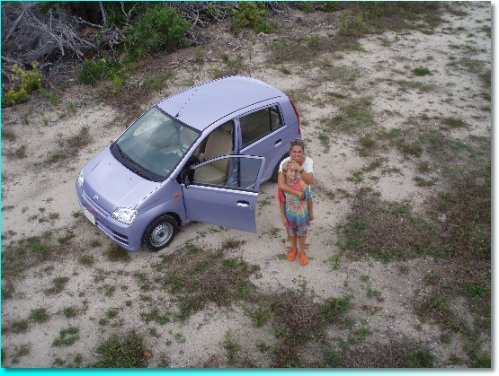
Well, I’ve peaked my heart rate from just recalling our entrance, so let me move on to the next day! It was Mother’s Day! Poor Karen… marrying a boater and living in New England is not a good combination for being appreciated on Mother’s Day. Spring is the time when the grinders, sanders and paint brushes are employed in the yearly homage to boat launch preparations. A couple years back, my friend Steve Lawrence and I sailed our newly launched boat up the coast to Portland on Mother’s Day weekend. Leaving our wives home alone with our children while their neighbors were having grand brunches and massage treatments was a fact not treated lightly! Then, last spring, we were so busy getting Thalia ready and the house packed, Mother’s Day got only passing attention. But, on this Mother’s Day morning, we were settled into the calmest anchorage Mother Nature could invent, and I knew this was the year to make amends. After a hot breakfast, and gift giving with home-made gift cards, we were ready to venture ashore. The town of Provo is inland far enough from the water that a rental car was the most practical choice, so we all squeezed into a “subcompact” Daihatsu Charade. By gosh, “subcompact” was a generous term – this thing was tiny!
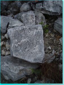
We had been warned that Provo was not an island that had put a lot of thought into city planning and growth management. By gosh, they were not kidding! This was definitely an island that was popular with tourists and in the midst of a huge growth spurt, but it was as if the developers were allowed to run amok and put strip malls, gas stations, resort hotels, and housing developments in a random order along the one, and until recently only, paved main road, Leeward Highway. Still, we found a nice big grocery store, a couple hardware stores and at least one internet cafe – the menagerie of items needed by most cruisers! In search of some sightseeing, we headed to a spot called Sapodilla Hill, parked the car and hiked the few steps to the top. After all, these islands have nothing close to the heights of a volcanic mountain. At the top were several engraved stones. According to local lore, these markings were the work of shipwrecked sailors from the 18th century.

Our next stop was what the map labeled “National Park” on the northwest corner of the island. The paved road turned into a dirt road, which then turned into a sandy stretch best suited to a dune buggy. Curiously, we passed several of those big signs and flags developers put up when they are introducing a new resort or condo development. We noted that it was odd for such development in a national park. When the road ended abruptly at a beach head, we got out and were surprised to find piles of garbage around and a stretch of isolated beach that would be fine for strolling were it not for a thicket of blood-thirsty mosquitoes. Assuming the Turks and Caicos had a ways to go in their National Park agenda, we turned our little Charade around in its 10 foot turning radius and headed back into town!
I had given Karen a choice of breakfast, lunch or dinner ashore and, not too surprisingly, she chose dinner. I’m not sure if it was the couple of glasses of wine she consumed or just our good fortune, but when we returned to the boat that evening, Karen proclaimed this day to be her best ever Mother’s Day! The kids slapped hands in self-congratulations – mission accomplished!
With our sightseeing done, brief as it was in and among the continual stretch of resort developments that marked this island, we loaded up with groceries, diesel and water and mentally began to prepare ourselves for the running of the gauntlet again. The anxiety of our planned exit was just below the surface for me and I think Karen the whole time we were on the island. “How were we going to get out safely?”, the question would not leave my brain. We perused the chart again and reviewed the track line that the GPS had labeled of our approach. How hard could this be, if we simply followed the track line back out? On the morning of our departure, the sun was not as bright as several of those pesky dark clouds hovered around our periphery. We could still see into the water, the winds were right and we didn’t need any reminders that there was still a lot of water to go to get to Marsh Harbour, Bahamas, our planned rendezvous point with our friends Martin and Nancy at the end of the month. We again assumed our same positions on the boat. This time, it was clear only three of us were stressed – our youngest sat in front of the depth sounder casually reading out the numbers with no apparent concern as they played with one of the ship models – or was that their way of dealing with stress?! We now had the current pushing out of the harbour, causing us again to travel over the ground at an uncomfortably faster speed than necessary. Near the sand bar that we had struck on the way in, we anchored once again and sounded ahead with the dinghy. We were having trouble finding “Narrows #2”. It looked like one continuous band of black and brown ahead of us. There should have been a narrow band of green, indicating sand, that would be the deeper passage. In the dinghy, we found a subtlety greener area, especially when the sun shone from time to time more brightly. We continued ahead in the dinghy to find “Narrows #1” but with out the GPS or our track line, I didn’t have a good reference point for finding it. We did find ourselves over a sizeable string of coral reef, and we decided we might just have to anchor Thalia again between Narrows 1 and 2 to sound again.
Back aboard Thalia, the skies were looking threatening. The winds were peaking at 20 knots on our stern and combined with the ebbing current, this was going to be very tricky. Karen took over the bow position and I took the helm. Wow, this was not easy; I could see what she had struggled with earlier. It is hard to hear what the person on the bow is saying while you mix their comments with what you are seeing on the GPS. The worst is when someone spotting says “It’s getting really shallow!” What do you do with this information at the helm?! I’m still seeing 5 feet under the keel. Do I turn, stop, go back? But look at those nasty clouds. This is no place to be stuck at, even at anchor, during a thunderstorm. Coral heads encircled us, like a swarm of angry savages, waiting to pierce our hull and send us to the bottom. We eventually found the small green patch of Narrows #2 and the depth was as low as 3 feet below the keel. OK, one more and we are done. I started making the turn to the right, following our track line, but going slow to be safe. It was surprisingly difficult to keep on the track line. One second I was 50 feet to the left and I would turn, and then I’d be 50 feet to the right. That was much too far off course for safety. I now had Karen and Zack continually yelling out what they were seeing on the bow, over the roar of the wind, and I was trying to jive this with what the chart showed and the ever allusive pursuit of the track line. After the slightest course change, the GPS would repaint the screen, making the confusion even more pronounced. As we finally approached what should be Narrows #1, I was too far to the left of our track line and planned to turn to the right, but Karen was yelling back that by no means should I go right – there was a huge coral head there! She insisted, demanded is more accurate, that I go to the left more. But, wow, to the left on the chart showed one of those nerve rattling plus signs – a coral head as well! What to do? The cloud layer suddenly covered the sun completely and Karen could only see directly below the bow. We had no way to look into the future, just the present. Finally, I decided to try heading back to the track line; this just was not making any sense. Shortly, Karen screamed out, in an expression so full of fright I could have sworn she was possessed by the devil, that is how much fear was inside her. They both asked me, “Are you aground?” No, I thought, we’ve got 2.5 feet under the keel – not a lot but not aground. Regardless, I throw the engine in to full reverse. This was short-lived, though, as I had no idea if I was going to back down on a coral head. All Karen and Zack could see was coral heads passing just under our bow. I clinched my whole body in that response to impending doom, waiting for the sound of lead keel vs. coral head. The depthsounder dipped down to 2.5 again, then 2, then 2.5, then 4. I exclaimed “It is getting deeper!” But then it went down to 3 for a moment, and finally shot up to 10 feet, we were free of the last narrows, based on about 10% skill and 90% luck. We all convened in the cockpit for the rest of the trip out the channel, having no suitable words to express our horror at what we had just experienced. I knew I would need a few days to come down from this one, and we still had the Bahamas, renowned for their shallow waters, ahead of us!
There would be time soon enough to evaluate what we had done wrong and what to change, but we had an overnight passage to San Salvador, 200 miles away, to focus on. Giving us no rest, Mother Nature transformed the dark clouds that had stolen our sun into rain and lightning. We switched into lightning avoidance mode, watching the radar and trying to guess each storm’s direction as we headed sometimes way to the left, sometimes way to the right, but rarely on the course to our destination. The wind was right at our back, making all of the dark clouds behind us a threat. Clearly, there would be no school work today!
At about 10 miles offshore of Provo, we were in deep enough water and out of the protection of the island to start to feel the effects of a strong swell coming in from the northeast, together with wind whipped waves from the east. With two predominant wave patterns, Thalia undulated in an unnatural motion, and throughout the day we all fought off feelings of mal de mar. Into the night, the winds fluctuated from light to strong to light, but the erratic wave patterns continued. Karen spent most of her watch eyeing the sky upwind of us for lightning, and when I took over for my 10pm-1am watch, the radar screen showed a continual march of rain-packed dark spots approaching from our stern. Some of these showed occasional lightning, and my dodging techniques proved futile as they gradually filled in the screen with a long band of darkness astern; evidently, there are some thunderstorms Mother Nature didn’t intend for you to outrun. The rain was continuous at this point, and we were sailing with just a reefed jib and making 7 knots. My body was beat, physically and emotionally, from the day, and when 1am arrived, I was fantasizing about how good the berth was going to feel. Unfortunately, Karen had not slept much at all, worrying as we all were about lightning and every little new sound on the boat as it rolled and pitched in the seas. This was not the Best Western in San Juan, by any means! When you awake in the darkness to start a watch, it can be confusing and worrisome, as the boat launches you and your family through the black of night at 7 or more knots. It can take 30 minutes or more to fully wake and get used to your new surroundings. Karen really wanted some company and I tried my best to provide this, but I just couldn’t keep my head from nodding off to the left, right and center. Seeing that I was pretty worthless company, Karen told me to go below. I was so tired, no amount of money would have dissuaded me from a direct path to our bunk. 4am came and went as I slept through my alarm, and Karen woke me for my penitence in the battle of darkness and rain up on deck.
With the first light of a new day, my anxiety dropped considerably. Clearly seeing the dark clouds around you somehow felt a lot better than what my mind had imagined their size and menace to be in the darkness. Karen greeted us with toasted bagels, just about all our sensitive stomachs could handle in the heavy seas. We pushed on during the day to San Salvador, under improving skies, and dropped our anchor in the bluest of blue waters I could have possibly imagined, off the main town of Cockburn Harbour. Since we had ran the gauntlet in Provo 36 hours ago, we were in some serious need for R&R.
We chose San Salvador partly because it was a Port of Entry into the Bahamas; many of the surrounding islands in this part of the southern Bahamas looked interesting but we needed to be cleared in through customs first. San Salvador also claimed to be the location where Christopher Columbus first landed in 1492. As you might imagine, there is a lot of Columbus lore in these waters, and no less than nine different islands have claimed to be the first landing place. The National Geographic Society researched Columbus’ logs, most recently in 1986, and cast doubt on San Salvador, but apparently Columbus was secretive in his logs for fear of frightening his crew on how far they had sailed from Spain. So, who knows for sure. Oddly, San Salvadorians have placed an underwater plaque just south of our anchorage were they claim Columbus’ anchor rested. Now that should make you wonder! But we took the bait anyway and longed for a chance to explore ashore.
The next morning, I beached the dinghy and walked a mile to the airport to clear in. The Bahamas has the dubious distinction of charging the most to clear in – $300! We have cruised nowhere this year where the fees have been anything close to that, and when the Bahamas announced these new fees a few years ago, there were a lot of angry cruisers. In most islands in the Caribbean, it would cost us between $15 and $40. In some, like the French islands, there’s no charge. Perhaps the Bahamas, with its proximity to Florida, feels like it can get away with it. It is too bad they don’t look at the money that cruisers bring in to the community, like any other tourists visiting the islands.
Once I returned to Thalia after drenching myself in the surf launching the dinghy, I found the crew anxious to set foot on land. However, darkened clouds and lightning in the distance caused us concern. Alas, our plans to go ashore as a family were nixed. By day’s end, there was a lot of grumbling about how the Bahamas had too much rain. The exhaustion of our push from Puerto Rico, the frequent lightning, and the rain were accumulating in our psyche and drawing our spirits down. Fuses were short and tempers were easily aroused. We desperately needed some happy medicine and fast! I’m sure you can recall a vacation you’ve taken where you arrived at a point in your travels where you are down and out and would really rather be back home. You might hold these thoughts to yourself, or share them with your companions, but either way, it’s blues-ville. What’s worse is a feeling of guilt that here you are on a hard-earned vacation and you should be enjoying yourself, yet you can’t get to that happy place! That was exactly were we were at. I could easily picture friends of ours at home thinking about what a wonderful time our family must be having in the Bahamas, sailing under blue skies and gentle seas, sipping wine, and watching as our children effortlessly completed their day’s schooling. Hah! What I most wanted at this point was to find a warm fire and an intriguing novel back on terra firma.
Since we were stuck on the boat, we tried to get the kids to start on the next day’s lessons, but school work at 5pm held little appeal and we soon called off the plans. At this point, the winds had clocked around to the west and increased to about 15 knots. Since we were anchored on the western shore, normally protected from the prevailing easterly trade winds, we were uncomfortably exposed. We had what boaters call a ‘lee’ shore, or land too close down wind from us. If we dragged or our anchor failed, we’d be on the beach too quick to respond. There was only one other boat anchored nearby, about the same size as Thalia, and we were both pitching up and down in the increasing waves. First our bow would rise up on a wave, then it come crashing down, and when it rose again, the stern, with its flat swim platform, would slam against the water shooting spray horizontal like Big Brother Billy’s impressive summertime cannonball dive. At times, the whole swim platform would be awash in water as the bow rose on a large wave. The worst of the conditions was in the middle of the night, as always, when one’s imagination fills in the void of visibility with doubts and demons. I awoke in the middle of the night to hear the automatic bilge pump kick on. Yikes, what is that about?! The wash of water on the swim platform had slowly filled the locker underneath it, which caused water to find its way down into the bilge. At first light, I emptied the locker of its gear and bailed out the water, which thankfully halted the ingress of water and the periodic running of the bilge pump.
At one point in the middle of the night, with sleep not coming easily, Karen and I poured over the charts to see where we could go for protection from such a west wind. There was nothing within a day’s sail. Should we just give up and sail overnight to Marsh Harbor and be done with these bothersome Bahamas sooner rather than later, we thought. I downloaded new weather forecasts and the westerly winds were to continue throughout the day with more rain possible. Wow, another day stuck onboard, while the sights of San Salvador called us from ashore. Could we really cook and eat and read and watch enough movies to occupy us below deck for the whole day and another restless night? Lord, levitate me to that cozy New England fireplace now.
Looking back on this day, the other factor at play with our mood was our vast isolation in these waters. Gone were the days of our companionship with rally boats like Asseance, Arctic Tern, Heaven Won’t Wait and Villomee. Gone were boats period, at least our kin with a big stick and canvas. Since leaving Puerto Rico 11 days and 600 miles ago, we had seen a few freighters and a few more sport fishing boats underway, but only one other sailboat underway – Summer Wind – a Rhode Island boat that was on its way to Charleston, SC and only diverted to Grand Turk to make repairs. We had met another sailboat, Dalliance, in St Croix — also with Portsmouth on their stern, but the one in RI, not NH — and we agreed to talk on the SSB as our mutual plans took us both through the Bahamas. But, unfortunately, they were 3-4 days behind us and mostly out of radio range. This was one lonely stretch of highway. A little bit of company would have gone a long way towards healing our spirits.
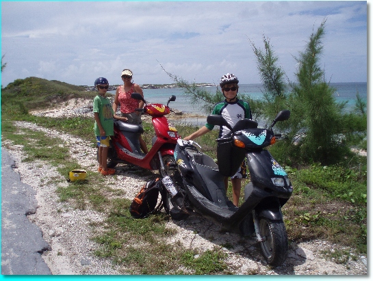
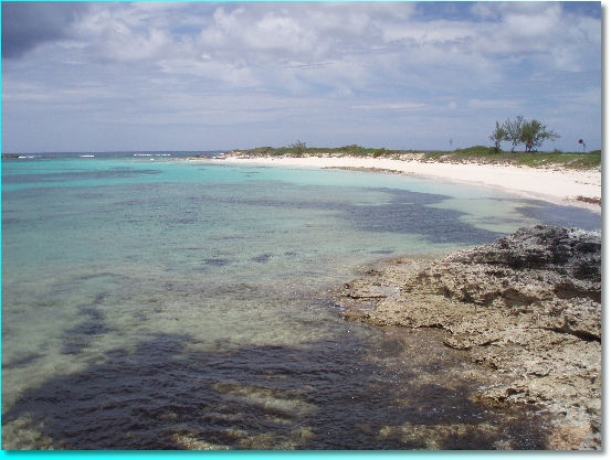
But, instead, our source of healing came in a different form. After breakfast, the sun started to break through the clouds. The wind eased ever so slightly, and the prospect of leaving the boat unattended while we explored ashore seemed like a possibility. We donned bathing suits and packed towels and snacks, piled into the dinghy and found a nicely protected marina nearby that didn’t mind us parking our dinghy at their dock for the day. I had a plan, and it involved a walk to K’s Scooters, at the airport. Sure enough, they were open and willing to serve us. A half hour later, we were saddled up on two scooters and driving down the road with the broadest smiles you could imagine! Salvation!San Salvador has the special benefit of a paved road around its entire perimeter, making the scooter a perfect venue to see the island. Our first stop was Graham’s Harbor on the northern side. Here the water was sparklingly clear, and the sand a slight pinkish hue, with some streaks of blue. We broke the glassy calm with an enjoyable and refreshing dip in the water.
Continuing around the northern end, we came upon a lighthouse, one of only three in the world that are hand-wound every two hours at night, using weights descending down the entire length of the tower – kind of like an old grandfather clock. Using a special vapor burner and Fresnel lens, it concentrated the light out 19 miles at sea.
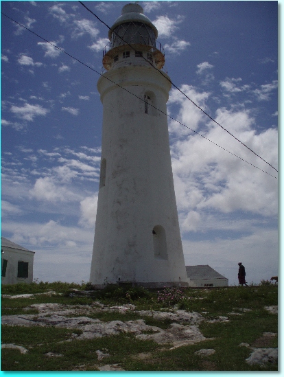
Once we climbed the 81 steps inside the tower, we were struck with awe as the gears suddenly started spinning and the entire lens mechanism began turning. Had we tripped something by accident! It was making a loud rattling noise and even with an engineering degree I couldn’t possibly figure out which lever might bring the contraption to a halt. So, I took a movie of the mechanism for you to see, and then we made a prompt exit!
After enduring a steady rain storm (is there ever a day here that does not serve up rain??) pelting our faces with needle-pointed raindrops, we found some ruins of an old castle building, and then stopped to take in the Columbus monument, on the beach at the supposed site where he came ashore.
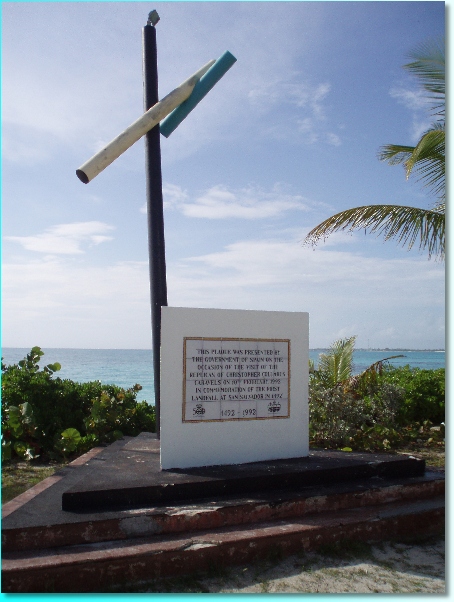
It was a very unassuming spot. Right in front of this plaque was a makeshift beach volleyball court, and a nearby Christian Cross and set of celebratory flagpoles were in a steady state of decline. Still, it was cool to think that 500 years ago Columbus was greeted here by the local Lucayan indians.
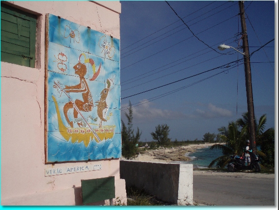
We ended our circumnavigation of the island at this whimsical mural.
Likewise, we found our whimsical spirits arisen, and were ready to embark on our next passage, to nearby Cat Island. Keep those home fires burning, though; we’ll definitely need them next winter, until our blood thickens up again!